
Author:
Audience Rating:
Publication:
Genre:
TG Universes & Series:
Other Keywords:
Permission:
Here there are stored various pdf files of maps of areas in the Anmar world created by Penny Lane.
Contents will be added from time to time.
Please note that the .pdf files can be accessed either by clicking on the appropriate entry in the list at the bottom of this post, or by simply clicking on the picture of the map.
These maps are copyright 2014 - 2023 Di Wonder and Julia Phillips.
C O N T E N T S :
~o~O~o~
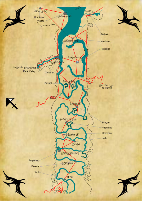
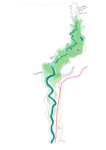
The first to be shown and stored here is a Palarandi map of the Great Valley from Yod to the Sea.
Please note two things:
a) that Blackstone DOES NOT APPEAR on this map, and
b) the map shows only limited details outside of the Great Valley. Many of these countries have an hinterland above the shoulder of the Great Valley.
We know from the Chivan roadstone, (#65), that Blackstone is 183 marks distant from Dekarran.
The story itself tells us (quite often - originally in #35, then in #36, #41, #49 and #65) where Blackstone lies, which is up the Palar Valley and then up the Bray Valley, and in #66 the detailed descriptions start.
This map shows just the lower reaches of the Palar, which joins the mighty Sirrel at Dekarran. It shows details upstream as far as Teldor. It does NOT show any further upstream along the Palar, where of course Haligo, Holville and Tranidor lurk before getting near to Garia's lands.
~o~O~o~
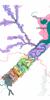
The second to be shown and stored here is a Palarandi map of the Central Part of the Great Valley, showing also the crest lines in the mountains immediately adjacent.

~o~O~o~
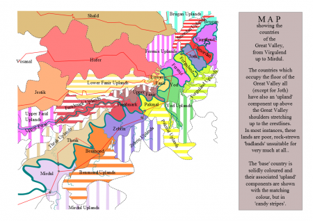
The third to be shown and stored here is NOT a 'Palarandi' original map. It shows a little more of the Great Valley, further upstream. It shows not just the countries themselves but also the crestlines and the areas of 'uplands' that belong to the 'base' countries.

~o~O~o~
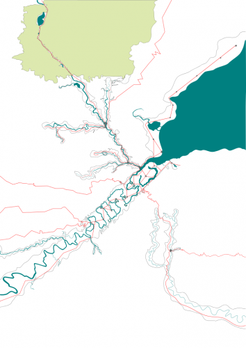
The fourth to be shown and stored here is a Palarandi map of the Palar Valley as far upstream as Tranidor and a little beyond.

Please note that Blackstone DOES NOT APPEAR on this map either.
This map goes as far as the fork in the trade route that leads to Chaarn, some 20 or so marks south of Blackstone through the forest.
~o~O~o~
The fifth to be shown and stored here is of the Bray Valley. It shows the wooded area, colour-shaded with the thick forest and the less dense areas. I need to make this absolutely clear, according to some PMs I have had: the two colours used here represent DENSE forest (the darker colour) and THICK forest (the lighter colour); outside of these areas, the terrain could be farmland or woods, or, and this is important, THIN forest.
~o~O~o~
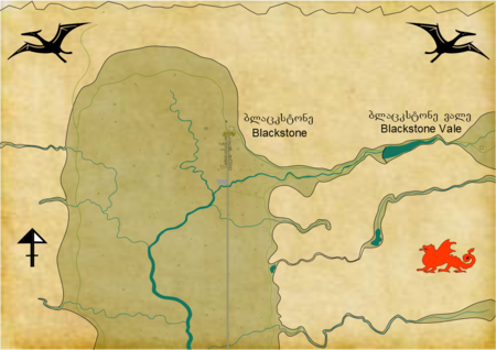
The sixth to be shown and stored here is of Blackstone and its immediate environs. It shows the area around Blackstone and includes the head of the Bray Valley, and out to just the start of the wider part of Blackstone Vale.
A jagged marker at the top indicates the start of the Stone Sea.
Please note: There are actually now TWO entries here. I have included an updated version now new roads have been (or will soon be) built and so on. A more detailed description of some of the features may be obtained from reading the chapter #68 in JoB Book Two.

~o~O~o~
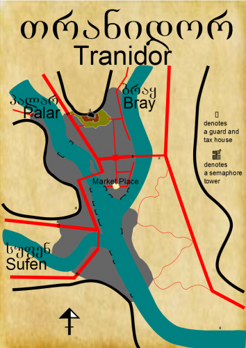
The seventh to be shown and stored here is of Tranidor and its immediate environs. It is the final Palarandi map.
It shows the area around Tranidor, the town built-up area, the rivers and Lord Trosanar's castle with the inner and outer baileys. It has been updated (2015.03.11) to show Junction Square, the semaphore towers and so on.

~o~O~o~
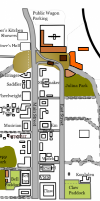
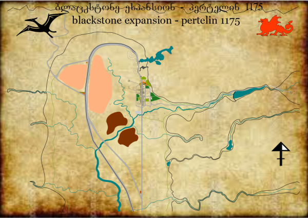
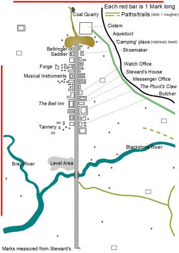
The eighth to be shown and stored here is not a 'Palarandi original'. It is provided as an aid to readers since it shows the main street in Blackstone, with some of the buildings identified. You can decide for yourself which of the other buildings belong to the draper, or the paint store, or the mason, or the carpenter, or the Wheelwright who does wagon repairs, or the dried seed merchant or the .......
Please note that this is NOT an attempt to map all the buildings in Blackstone, just those which are quite near the Main Street.
There is a small legend of some notation uses, which uses also appear in the previous map.

~o~O~o~
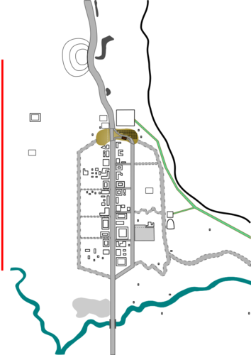
The ninth to be shown and stored here is also not a 'Palarandi original'. It is provided as an aid to readers since it shows the expected layout of Blackstone, the Town Planners vision.
Please note that this is NOT an attempt to map all the buildings in Blackstone, just those which are prominent.

~o~O~o~
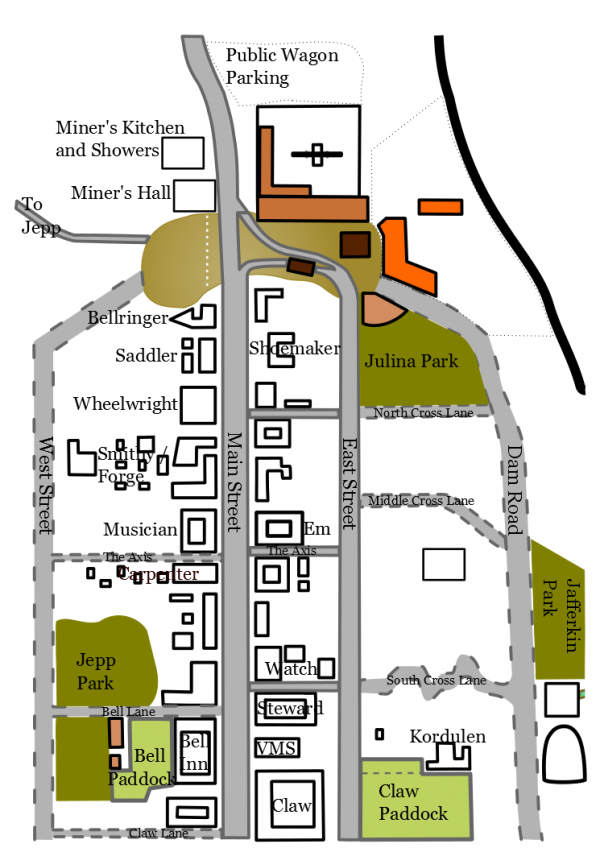
The tenth to be shown and stored here is a close up of Blackstone as it develops. It is to help associate names of roads and buildings etc etc.
.
~o~O~o~
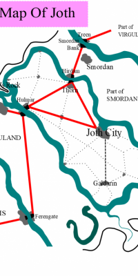
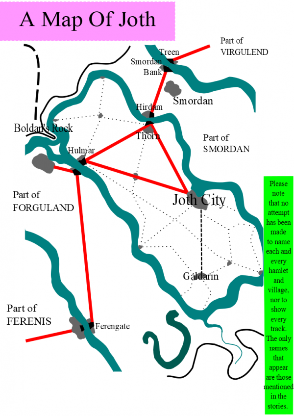
The eleventh to be shown and stored here is also not a 'Palarandi original'. It is provided as an aid to readers since it shows the outline layout of Joth, with snatches from surrounding countries.
Please note that this is NOT an attempt to map all the villages, hamlets, roads, tracks, streets, just those which are prominent or are mentioned in the story/stories.
~o~O~o~
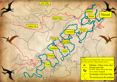
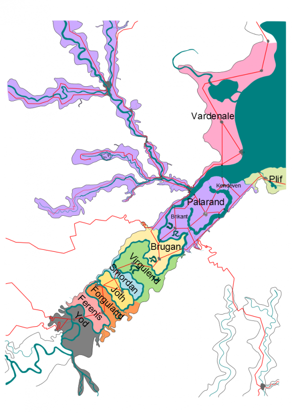
The twelfth to be shown and stored here is an overall map which shows the political boundaries. This also is not a 'Palarandi original' - just an overall picture designed to aid the reader to place everything in relation to all the other places mentioned in the story as being either in a part of Palarand or in the Great Valley near Palarand.
Again I mention that only the major features are shown, no high mountain valleys, no roads other than the 'trunk' roads, and so on and so forth. Space limitations meant that this map is cut off also just 20 marks or so south of Blackstone.
Please note two things:
a) that Blackstone DOES NOT APPEAR on this map either, and
b) that this map does NOT show the above-the shoulder hinterlands for the Great Valley countries.
~o~O~o~
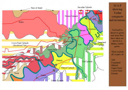
The thirteenth to be shown and stored here is NOT a 'Palarandi' original map. It shows a little more of the Great Valley, further upstream. It shows not just the countries themselves but also the crestlines and the areas of 'uplands' that belong to the 'base' countries. This is a close-up of the third map, but with Yod and its conquests marked.

~o~O~o~
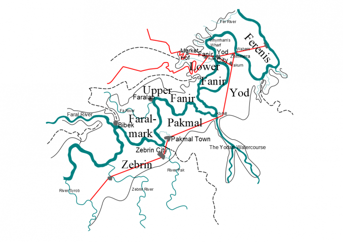
The fourteenth to be shown and stored here is also NOT a 'Palarandi' original map. It shows a more ‘local’ map of some of the Great Valley, around Yod. This is more of a close-up of the lands from Ferenis to Faralmark and Zebrin.

~o~O~o~
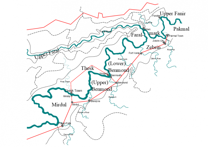
The fifteenth to be shown and stored here is also NOT a 'Palarandi' original map. It shows a more ‘local’ map of some of the Great Valley, upstream along the Sirrel from Faralmark. This is more of a close-up of these lands up to Mirdul.

~o~O~o~
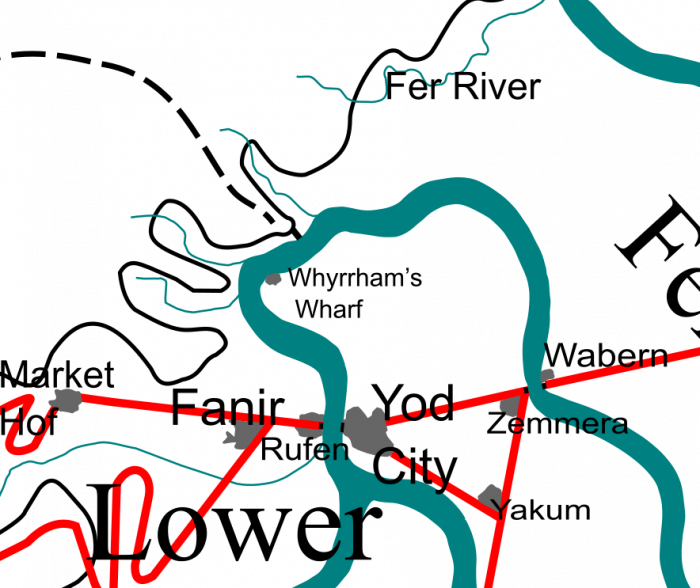
The sixteenth to be shown and stored here is also NOT a 'Palarandi' original map. It is simply an extracted close-up of the Sirrel around Ferenis, North Yod and parts of Lower Fanir.

~o~O~o~
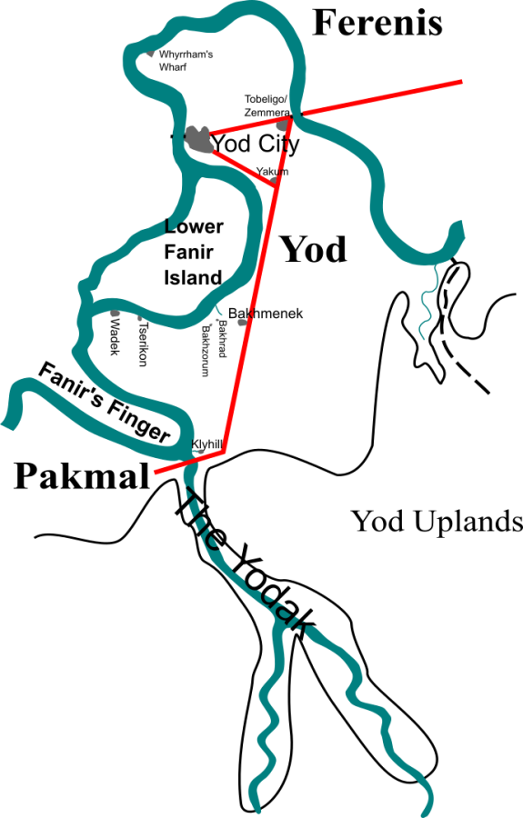
The seventeenth to be shown and stored here is also NOT a 'Palarandi' original map. It is a bare map of the towns and villages in Yod.

~o~O~o~
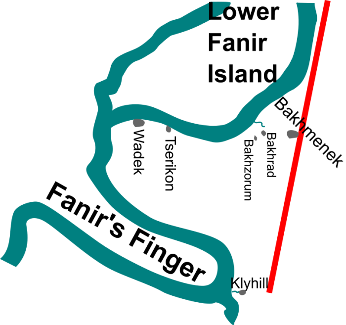
The eighteenth to be shown and stored here is also NOT a 'Palarandi' original map. It is simply a blow up of a strip across the centre and south of Yod.

~o~O~o~
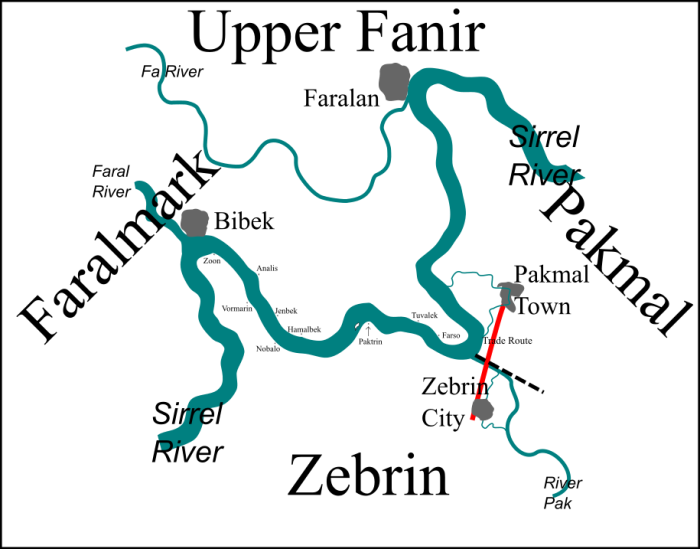
The nineteenth is a closer-up view of the stretch of the Sirrel basically from Bibek in Faral down to the Pakmal/Zebrin border. Continuations of the river are given for context at either end.

~o~O~o~
The twentieth is simply a read-off distance chart for places of interest from Dekarran to Blackstone.
It is set up here as an HTML table.
It shows distances along the Bray/Palar valley and all distances have been rounded to the nearest half-mark.
It may be interesting to know that distances are measured from the Steward's House in the centre of Blackstone Town.
| Blackstone (BS) | BS
|
||||||||||
| Forest Roadhouse (RH) |
22
|
RH
|
|||||||||
| Bezlet (BT) |
31.5
|
9.5
|
BT
|
||||||||
| Chaarn Fork (CF) |
39
|
17
|
7.5
|
CF
|
|||||||
| Brayview (BV) |
44
|
22
|
12.5
|
5
|
BV
|
||||||
| Tranidor (TR) |
68
|
46
|
36.5
|
29
|
24
|
TR
|
|||||
| Holville (HV) |
91
|
69
|
59.5
|
52
|
47
|
23
|
HV
|
||||
| Toomer's Gulley (TG) |
99
|
77
|
67.5
|
60
|
55
|
31
|
8
|
TG
|
|||
| Haligo (HA) |
118
|
96
|
86.5
|
79
|
74
|
50
|
27
|
19
|
HA
|
||
| Teldor (TE) |
153.5
|
131.5
|
122
|
114.5
|
109.5
|
85.5
|
62.5
|
54.5
|
35.5
|
TE
|
|
| Dekarran (DE) |
183
|
161
|
151.5
|
144
|
139
|
115
|
92
|
84
|
65
|
29.5
|
DE
|
~o~O~o~
Here are the .pdf file links again
01. Great Valley Yod to the Sea.pdf (240.23 KB)
02. Great Valley Central with Crestlines.pdf (231.08 KB)
03. Great Valley Virgulend to Mirdul with Crestlines.pdf (378.46 KB)
04. Palar and Bray Valley from above Tranidor to Dekarran.pdf (157.99 KB)
05. Bray Valley Woods and Forests.pdf (178.20 KB)
06. Blackstone and Valley Heads.pdf (152.66 KB)
... 06a. Blackstone and Valley Heads LS parch 202.pdf (183.02 KB) See chapter #68 of JoB for a detailed description of some of the features.
07. Tranidor Palarandi map.pdf (111.19 KB)
08. Blackstone from coal quarry to first markstone.pdf (35.70 KB)
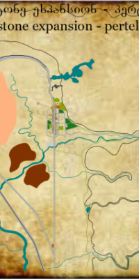
09. Blackstone expansion.pdf (14.90 KB)
10. Blackstone development.pdf (37.54 KB)
11. Joth for readers.pdf (45.22 KB)
12. Great Valley and Palarand Political boundaries.pdf (166.66 KB)
13. Close-up of Yod conquests.pdf (220.34 KB)
14. Villages from Ferenis to Zebrin.pdf (64.90 KB)
15. Villages from Mirdul to Faralmark.pdf (61.83 KB)
16. Sirrel round North Yod.pdf (61.92KB)
17. Yod Towns and Villages .pdf (64.46KB)
18. Central/South Yod .pdf(29.22KB)
19. Sirrel from Bibek down to Zebrin.pdf(36.30KB)
~o~O~o~
And here are links to the .png files
01. Great Valley Yod to the Sea.png (543.19 KB)
02. Great Valley Central with Crestlines.png (208.67 KB)
03. Great Valley Virgulend to Mirdul with Crestlines.png (159.06 KB)
04. Palar and Bray Valley from above Tranidor to Dekarran.png (883.74 KB)
05. Bray Valley Woods and Forests.png (126.46 KB)
06. Blackstone and Valley Heads.png (724.61 KB)
… … ... 06a. Blackstone and Valley Heads LS parch 202.png (375.05 KB) See chapter #68 of JoB for a detailed description of some of the features.
07. Tranidor Palarandi map.png (200.46 KB)
08. Blackstone from coal quarry to first markstone.png (195.83 KB)
09. Blackstone expansion.png (61.52 KB)
10. Blackstone development (314.87 KB)
11. Joth for readers.png (134.64 KB)
12. Great Valley and Palarand Political boundaries.png (375.14 KB)
13. Close-up of Yod conquests.png (160.24 KB)
14. Villages Ferenis to Zebrin.png (99.22 KB)
15. Villages Mirdul to Faralmark.png (102.74 KB)
16. Sirrel round North Yod.png (207.85KB)
17. Yod Towns and Villages.png (111.64KB)
18. Central/South Yod.png (77.75KB)
19. Sirrel from Bibek down to Zebrin.png (67.74KB)
Working overviews:

If you liked this post, you can leave a comment and/or a kudos!
Click the Thumbs Up! button below to leave the author a kudos:
And please, remember to comment, too! Thanks.


Comments
Either I don´t see or am blind,
...because I see no link on pdf to download. Only small picture of the map. And that too small to see any detail.
Blame it on the newbie
Sorry about that.
When I published it, I added in all the details of the pdf.
So where did I go wrong?
Have to think about that ......
Duh ....
... I probably added in the link to my hard drive rather than to BCTS's store.... lemme go see if I can do that now ....
Either I don´t see or am blind
The link is just under the thumbnail picture.
Best,
DJ
Di, you have
done a most excellent job on Great Valley from Yod to the Sea.
May Your Light Forever Shine
Hmmm......
Not how I expected it. Can it be converted to google maps ??? we could zoom in and have a look around the streets then ;)
and one more thing
A point in future for any one with poor eyes or small images on a screen. You can zoom the screen in to enlarge writing or pictures to see the extra detale.
Magnifying
True as regards the zooming on the screen.
However, the BIG difference is that the image there is a .png and, although created with the same program (Inkscape), it does not have the depth of detail. With the .pdf version you can zoom in until a town name fills your screen and it remains in focus.
Cheers, Di
(P.S. although I wouldn't classify myself as an expert, I am quite handy using Inkscape and could offer help to anyone who may consider using it for their own purposes)
Inkscape
As the map expands, you may even be able to save it as an svg... :)
Meanwhile, I notice the script text appears to be a direct transliteration of the English (am I observant or what?!)
One question: is the tributary SW of Dekarran with the road crossing it multiple times Blackstone Valley, or is that elsewhere?
As the right side of the brain controls the left side of the body, then only left-handers are in their right mind!
SW of Dekarran
Not Blackstone. It is probably the river that Keran's grandfather participated in a battle. I would have to check my notes for the name of that river. Blackstone is conciderably farther along up the tributary that ends at Dekarran.
Formats and an answer
Hi there
the maps are all stored as svg versions, but it is not possible to load these types of extensions up into this site.
And a pdf is less than half the size of the png, and just over half the size of the svg.
Yes, the Palarandi script we have used is a transliteration, it was, frankly, the easiest solution to just download a font, rather than have to develop an entire language.
As regards that other valley, then it is actually extraneous to the story and is therefore unnamed, to try to reduce 'clutter'. I like Payter's suggestion that it might lead to the Perent River, where there was a battle in Keren's grandfather's time.
Just a small technical point, please note that that tributary valley is NOT really to the SW, but is more to the W as the map does NOT point upwards to North.
Blackstone is 183 marks from Dekarran up the Palar Valley
Enjoy this and the soon-to-arrive other maps.
Di.
Map
I see the roads comming out of Dekarran but where is Black Stone?
For those who don't see it, the PDF link is just under the thumbnail picture.
Best,
DJ
Geography
As we know from the roman milestone, Blackstone is 183 marks from Dekarran, way up the Palar Valley.
This map only shows the Great Valley .... another showing the Palar Valey will be posted in a few days.
This map does actually show the Palar Valley as far as Teldor, which is around 36 road marks (as opposed to Ptuvil-flying marks) from Dekarran.
The Great Valley is roughly 60 marks wide, so there is 3 times that distance to go up the side valley.
Cheers
Di
Geography
Actually, the Romans had kilometer stones that compare almost exactly to the mark stones.
DJ
Not a lot of people know ....
.... that the Romans (whatever have they done for us?) were actually quite short (and not just the Romans in those days) and that our word 'mile' comes from the Latin for 'one thousand' or rather the phrase 'one thousand paces'; indeed the modern Italian word for 'one thousand' comes from that same word - 'mille'; we have millennium (plural millennia), millimeters (one thousandths of a meter), millipedes, millilitres, millivolts and so on.
Why is being short an important factor?
Because, for the Romans, a pace was from when one foot left the ground until that same foot left the ground again. In other words, a double stride in our parlance. So one pace was just about five and a quarter of our modern feet in length, a single step being between two and a half and two and three quarter feet .... times one thousand makes 5250 feet - our mile is nowadays more accurately measured at 5280 feet. The Romans actually placed their milestones (i.e. a stone every 1000 paces) to count one thousand of their paces. More modernly than the Roman era, countries changed the roadstones to every 1000 single strides, which is why their stones are nowadays placed a kilometre apart. Because the average height had changed, then a kilometre is slightly more than a half of a mile, roughly 5 eighths of a mile as it happens.
Kilometres
Actually, the km was invented by French scientists after the Revolution as an attempt to find a system of measurement that DIDN'T derive from humans, but from the Earth itself. It was based on a percentage of the Earth's circumference, and was derived without the knowledge that the planet is a bit squished in shape. The same system of unified measurements is why one litre of water weighs one kilogramme.
https://en.wikipedia.org/wiki/Metre
Kilometres
I stand corrected. That's what happens when you shoot from a rusty brain.
DJ
I don't care
Your suggestion SHOULD be the right one! It was delightful.
D'oh!
If you've been reading this tale closely enough, you'll have discovered that the "Chivan" Mark stones are, in fact, Roman milestones!
Penny
Alphabet
Ah well, now we start the transliteration as everyone did with the Tolkien books.... :-)
Exactly
...yes, Penny and I discussed the Palarandi 'letters' and this is what we came up with (after her suggestion put me on that track).
(It's actually just an available font of course, but the computer is a few hundred years away from Palarand right now)
It is about what I expected.
Thank you.
Gwenolyn
Wow...
I'd kinda figured as much with the way things were described, but I wasn't really realizing just HOW MUCH bigger Palarand was than all it's neighbors. It's by far easily the largest and richest of all the nations of the Valley. And I suspect that eventually they will swallow the entire Valley in time. It's almost inevitable with most of those "nations" being little more than city-states. Just like ancient Greece.
Palarand is the only true nation among them, and now has the greater knowledge and technology from Garia's contributions, with only Yod having anyone who can possibly provide the same, but knowing the way the Yodans operate it is unlikely they are getting near as much out of whoever it is they are holding.
I expect that Yod is going to conquer most of the nations upriver of Palarand, all the while trying to operate clandestinely inside Palarand before they eventually clash openly.
The other nations will at first join Palarandi efforts to subdue Yod in a more of a treaty type arrangement of alliance... Which alliance will slowly become more and more "Palarand rules" due simply to their having the obviously greater power. And their positioning in the Valley makes them an ideal central seat of governance when nations beyond the Valley inevitably begin to take up grievance. They command a sea port and two of the most major mountain passes, and the series of smaller valleys and steppe leading up from the Palar.
That geography alone puts them in a powerful position. And then to have Garia... A WILLING contributor to their greater wealth of knowledge and technology... Palarand is going to become Anmar's first superpower post-Chivans. And they are going to be peaceful about it. Yod was given an Earthling simply to push them into making the grievous error of pushing the assault, which they were already just itching to do. Putting the other nations into a position of either being swallowed viciously by Yod, or joining Palarand peacefully to resist.
Abigail Drew.
The size of Palarand
There's a certain fudginess about all this, since the maps are Di's creation and only based on my original descriptions. Yes, Palarand is large, but that's because (i) it swallowed up Brikant and Kendeven through force of circumstances, and (ii) it has the rich Palar Valley for metals. I would note that it is likely that some of the other states have access to side valleys. They haven't been mentioned in the story simply because there was no need to.
Fortunately relations with nearby states are mostly peaceful these days. Some of you have worked out the broad picture here of what the Vast, Multidimensional Beings (VMB's) are attempting to do and you're mostly correct.
You might find the end result to be somewhat surprising, though. I'll leave that for the story to reveal.
Penny
With the latest map...
Palarand just comes out looking even bigger! Though this latest map does reveal that Vardenale is actually far larger than just that tiny sliver of the Valley they hold, but that they actually hold quite a lot of coastal land. Vardenale looks like the second largest Valley nation. Even taking into consideration additional holdings for some of those countries, they can't be nearly as large as either Palarand or Vardenale. And by the sounds of things in-story Palarand and Vardenale get along quite marvelously as well. Which makes them a quite hefty beginning to that future alliance I was imagining.
Abigail Drew.
Thanks
Your graphic adds to the visualization of the story.
You can add a picture to a clickable link...
just as you can almost any visible HTML element. That would allow you to post a "thumbnail" in the Gazetteer which could easily be clicked upon to expand it to a better size to distinguish details.
If there's any confusion, you could add a caption telling people what to do to see the enlarged picture. A PDF may be a bit of overkill, though, since it adds a bit of overhead processing and usually takes longer to load than a straight gif or jpeg. Of course, it also does automatic scaling and scrolling, so the trade-off might be worth it.
-
Cheers,
Puddin'
A tender heart is an asset to an editor: it helps us be ruthless in a tactful way.
--- The Chicago Manual of Style
Storing maps.
Hi Puddin'
what the actuality is, I found quite surprising.
The overview map above is a .png and runs at 631 kilobytes. It was resized by the site (Drupal?).
It was developed in Inkscape and saved as an .svg which runs at 529 kilobytes - however, I suspect it is a limitation of Drupal, but we can NOT load up any .svg images, they are not on the 'allowed' list of extensions.
Inkscape (at least my version) does not give the option to save as a jpeg nor as a gif.
As for the .pdf, well that runs at a mere 238 kilobytes.
Not only does it provide the viewer with far more detail, it is also 'cheaper' on storage.
So each map (there are plenty more to come) is saved as a .svg, a .png and a .pdf
Cheers
Di.
Storing maps.
If it can be stored as a bmp file, is it on your allowed list of extensions? Just throwing ideas out.
DJ
Where are...
This is a wonderful map. A lot of work went into it. I have a couple of questions. Where are Blackstone and Tranidor? They and some of the other towns they traveled through aren't shown. Please help.
Much Love,
Valerie R
Geography
Hi Valerie,
As we know from the roman milestone, Blackstone is 183 marks from Dekarran, way up the Palar Valley.
This map only shows the Great Valley .... another showing the Palar Valey will be posted in a few days.
This map does actually show the Palar Valley as far as Teldor, which is around 36 road marks (as opposed to Ptuvil-flying marks) from Dekarran.
The Palar Valley then goes up through Haligo and on to Tranidor.
The Great Valley is roughly 60 marks wide, so there is 3 times that distance to go up the side valley.
A map of the Palar Valley will be posted in the next few days, but even that won't reach Blackstone (very nearly but not quite) as Blackstone is up a further valley off the Palar Valley.
Don't worry, it's all in the pipeline.
Cheers
Di
Just wondering...
In addition to these maps highlighting various bits of the territories, is there any chance of a small scale map showing the entirety of what is known (in considerably less detail, obviously!), to help us work out roughly the geographical relationship between town X1 on map Y1 with town X2 on map Y2? :)
Meanwhile, at the other end of the range of scales, Blackstone's going to be an interesting project, as not only do we know the medium scale (e.g. how far up the valley it is) but also the small scale (distance from town to nearby places like the covered reservoir and stone sea) and very small scale (selected buildings / locations within the town itself).
Of course, no sooner than you've got all those drawn than the action will return to Palarand itself, where we're quite likely to learn about a few more places in town other than the Palace, Guild Hall and a handful of industrial workshops.
As the right side of the brain controls the left side of the body, then only left-handers are in their right mind!
More maps? Ack!
I tell you what, I'll hold you down and Di can shoot you...
There is scope for different detail levels on maps of Blackstone which Di is presently looking at. She's about to become more busy in RL so don't hold your breath.
You're right, in that we're soon to leave Blackstone and return south. As to what happens when we get there, you'll just have to wait and see.
Penny
Returning
No doubt some of the first things we'll find out are (a) what the various Guilds have been up to in her absence, and (b) what Milsy's been up to (apart from electric-synchronised clocks!).
As the right side of the brain controls the left side of the body, then only left-handers are in their right mind!
Notation
No notation that: There be monsters here?
Huggles
Chelle_MM
Nice maps and they load pretty fast too
The other night it loaded very slow but maybe net traffic was high?
A map *legend* or *key* would be nice... as time permits.
I assume to get this much detail was a serious and time consuming effort.
Your hard work is appreicated.
John in Wauwatosa
John in Wauwatosa
Why can't I give a Kudo?
I tried to give a kudo to this, as I am fully aware of the time, effort and research required for such wonderfully stunning end results.
Thanks for putting it all together so splendidly.
Julia
Wow! Very Nice
Thanks so much. The creation of the maps was obviously not a trivial task.
Three questions...
1. Regarding the sixth "map": I don't see the point in putting that information in image form. What's wrong with offering that same info as a text (HTML) table?
2. Regarding the SVG source maps: would it be too much to ask to make them available for download, perhaps as a zip file if Drupal does not like SVG?
3. Regarding the thumbnails: as it is, they are rather hefty for the visible information and the image dimensions. PNGs don't compress pseudo-random textures, like that "old parchment" effect, very well. Maybe a JPG would be better for that purpose?
Three, and more, answers
The idea was to make the maps available to anyone (although I would still like to retain the copyright!) which means that there are some knock-on effects.
They are available in .png format and .pdf format at the moment, for what seem to me to be valid reasons.
There are still some computer users who do NOT have the ability to read .pdf files, therefore the .png files will have to suffice them.
I am thinking of providing just thumbnails for the page, as it is now getting noticeably slower to load the page, and then having a separate list of links to the .png files.
The distance table CAN be coded as a table - I was just extremely busy at that time, and I had had PM requests to provide that info. asap. So I just whacked it up there (and forgot about it).
As regards the formats available, as was mentioned in earlier replies, the maps were developed in a program called Inkscape.
Inkscape does not have the capability of producing either .jpeg or .gif files. At least my version of it does not.
The standard ('internal' format if you like) of Inkscape is .svg but these cannot be loaded into the BCTS area.
If you would really like a copy in .svg, then send me a PM and we'll discuss it.
The .pdf files are considerably smaller than the .png files and yet the .pdf files contain so much more with the zoom facility.
My therefore preferred format is .pdf, and the .png files are provided as an alternative for those who are unable to use .pdf files.
I am currently working on two other related projects and may have a number of other images to load in the next week or two, so I will probably edit this page then .....
All the best,
Di
I <3 Inkscape
Inkscape FTW!!!
I've used it for lots of other things. I used Inkscape for most of my abstract art I posted on my DA page. It never occurred to me to use it for map making. I use autorealm for my maps, but it's rarely updated and kind of clunky. I abhor Campaign Cartographer. I've even gone a few times and made hand drawn maps and scanned them in but I no longer have a scanner, and the scanner was the normal size so not that big.
I'm going to try Inkscape to make a map now that I've seen you do it.
Internet High Fives All Around
Stardraigh
( •_•)>⌐■-■
My Deviantart
(⌐■_■)
This is real cool
Such a lot of work in here
Thank you.
Savannah
One Quibble
These maps are handy, and fill a much-needed purpose. Some of us are visually-oriented, and need the graphics.
But one little quibble: there doesn't seem to be an instantly-recognizable map orientation. As you know, it is kind of an accepted practice by us Earth-dwelling solids to place 'North' at the top of the map. These maps don't seem to do that. That requires mentally juggleing the images, which in turn requires some thinking. That's tough to do, given a tendency to forget things! :-(
“When a clown moves into a palace, he doesn’t become a king. The palace becomes a circus.” - Turkish Proverb
Almost
Actually, with the sole exception of the maps of the lower Great Valley, that is the original maps showing the portion between Yod and the sea, north is always at the top. On that Great Valley map, the direction of north is indicated by a HUGE arrow to one side of the map.
Although the layout of the maps basically follows cartographic standards, such as they are, the arrangement of the maps caused some head scratching when Di suggested drawing these for me.
First, we weren't sure whether to show North or South, as the Great Valley is south of the equator. Earth only selected north and south relative to the direction of spin but Anmar doesn't have that history. Should they have a south pointer instead? We decided to go with North since it would otherwise be confusing for our readers (like you).
Second, there was a thought that those who live in the Great Valley would think of the axis of the valley as being the 'lengthwise' view they would have of their locality; that's why that map is drawn the way it is - and to save paper (and filespace). The big arrow was added later following complaints, if I remember correctly.
Penny
This PNG Map link is broken
This PNG Map link is broken
04. Palar and Bray Valley from above Tranidor to Dekarran.png (883.74 KB)
Getting a 404 Not Found Error
Not Found
The requested URL "/topshelf/system/files/u12540/Palar%20and%20Bray%20Valley%20from%20above%20Tranidor%20to%20Dekarran.png" was not found on this server.
All other links are working, it's just this one PNG file
Dark Elven Sissy Slut – Uhuru N’Uru
Now fixed - sorry!
Thanks for helping!
*smiles*