
Completely off-topic, but it may be of interest to Anglophiles...
Google have released a giant update to the UK street view coverage (the panoramic photos taken from Opal Astras with funky camera gear on top), taking it from a few major cities and patchy coverage elsewhere, to (they claim) 96% of UK roads.
Here's a few highlights, (inevitably) from Land's End to John O'Groats, plus a few extra locations thrown in for good measure.
Lizard Point (most Southerly point)
Land's End (most Westerly point)
Clifton Suspension Bridge
Severn Bridge
Aberystywth (mid Wales)
Llanfairpwllgwyngyllgogerychwyrndrobwllllantysiliogogogoch
(the long name was coined by a cobbler to drum up tourism... needless to say, it's a very dodgy rendering of the language!)
Menai Bridge
Blackpool (famous for it's tower)
Sellafield (fancy some plutonium?)
Gretna (marriages!)
Forth Rail Bridge
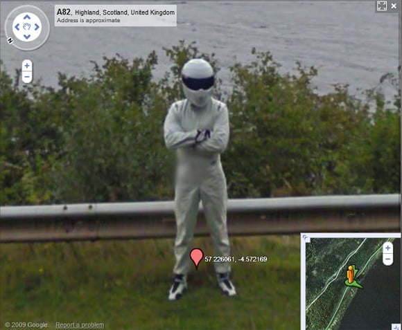
Loch Ness (What's that smudge? It used to look like this...)
Drumnadrochit (look at the user photo - that sign used to look a little different...)
Dunnett Head (most Northerly point)
John O'Groats (most North Easterly point)
Twatt (I kid you not!)
Gloup, Shetland (about as far North as you can go!)
Here be Vampires!
The town that doesn't exist... (Victorian entrepreneur laid out the roads for a new resort but largely failed to sell the adjoining land)
Naked Lady! (Thought that would get your attention)
Kenilworth Castle
Meet Will! (Or at least, the home of the RSC)

Comments
Its pretty good
Its been XX(X?) years since I left but I was able to cruise around my old flats in St John's Wood, visit my old schools. The chip shop in Camdentown is gone =( and the pet shop near to it is vacant. The news store where I bought my sweets is still open. I wish some other countries would do as well. My present home has pretty good coverage and a friend in Sweden has some amazing shots of her home, and garbage cans.
Not bad for an armchair holiday, think of all the airfare I just saved? I am still upset about the chippy but they would probably have changed to veg oil anyway.
Happy Travelling
Greetings
Think I have been to most of the places listed, except for those offshore in Orkney and Shetland.
Somewhere in my collection of souvenirs there is a platform ticket from Llanfairpwllgwyngyllgogerychwyrndrobwllllantysiliogogogoch, however, it has the abbreviated name Llanfair P.G.
Looking at local streets I recognise the images are several months old.
Brian
Not just "several" months old...
It's generally thought they're about 18-24 months old. When the cars were travelling through Warwick, there were banners helpfully advertising the annual cycle races... September 2008. Back in the days before Woolworths went into administration...
As the right side of the brain controls the left side of the body, then only left-handers are in their right mind!